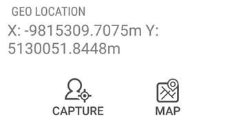
Capturing the Geo Location
Trimble Unity allows you to capture a location as part of the form data collection. This is captured in a geometry field and as such can be a point, a line or a polygon.
To capture the GPS location of the work order, tap the GEO LOCATION text area.

Do one of the following:
- Tap CAPTURE to capture the GPS position of your current location.
- Tap MAP to open the map. You can then hold the device still and tap the satellite button .
- A GPS position will be captured, and the geo location value will change to “Point”.
- If a GPS signal is not available, tap the pen button to manually enter the meter’s location on the map.
- Tap
 .
.
Once you have captured the GPS position of the location, the field changes to show the geometry of the position:
For several features such as lateral lines or water mains, you can capture a series of GPS positions as you move between the assets. This is called a GPS line feature.
-
Select the LOCATION/GPSINFORMATION tab:
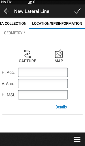
- Tap CAPTURE.
- As you move, Trimble Unity records your GPS position.
- When you are finished collecting assets, tap
 .
. - Tap MAP. The Capture line icon appears on the map.
On the Mapper apps, the form can be configured to capture GPS metadata, since these apps focus on high accuracy mapping of assets.