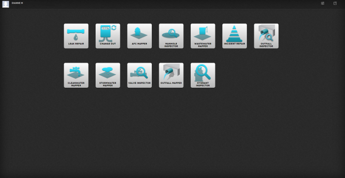
App Chooser screen
This is the App Chooser screen.
It is used to filter the type of workflows you want to be able to manage in the Trimble Unity Web.
The following list of apps are examples of workflows that can be configured in Trimble Unity. They are offered “out of the box”, however the Trimble Professional Services team can set up a specific workflow for your organization.
A summary of what each app does is presented below.
Selecting a particular app means only those types of work orders are shown.
TIP
Selecting a specific app in the App Chooser screen has benefits in terms of some of the functions in Trimble Unity Web. For example, when creating a work order with associated assets, only those asset types associated with that app will be selected, by default, when creating the work order (i.e. only hydrants selected for hydrant inspections) – otherwise you would have to manually filter out those assets not required. The app also can be configured to display certain GIS data based on the workflows associated to the app. For example, a wastewater app is configured to display wastewater GIS layers.
Once you select an app, the Work Order list appears.
Change Out
The Meter Change Out app is configured to plan, dispatch, and manage meter change out jobs. Field technicians can capture meter information, read the GPS location, and take before and after photographs of meters.
AFC Mapper
The AFC Mapper apps is configured for mapping American Flow Control hydrants and valves. It is configured to scan the manufacturer’s 2D barcodes, and automatically input the information into the data collection form. Technicians will be able to capture a high accuracy GPS position, take photos, and save the information to update your enterprise GIS.
Manhole Inspector
The Manhole Inspector app is configured using a subset of the NASCO standard, allowing field technicians to assess the condition of the manholes, take GPS positions, if needed, to update the location in the GIS, and add pictures to document specific condition observations. The data can be used for planning capital improvement and repairs.
Incident Repair
The Incident Repair app is configured to report, track, and respond to generic incidents occurring on the distribution network.
Mapper
Trimble Unity contains three Mapper apps: Stormwater Mapper, Wastewater Mapper, and Cleanwater Mapper. Each is configured using the standard Esri Local Government Information Model (LGIM), enabling users to collect asset location and attribute information associated to Water, Wastewater, and Stormwater networks.
Outfall Inspector
The Outfall Inspector app is configured to support DOTs (Department of Transportation), MS4s (Municipal Separate Storm Sewer System), or their contractors in recording the results of outfall inspections. The inspections have two purposes:
- General condition assessments, identifying damage to the facility and general maintenance requirements.
- Identification of suspect illicit discharges.
Valve Inspector
The Valve Inspector app is configured to plan, dispatch, and manage large valve inspection jobs, enabling field technicians to assess the condition of the valves, take accurate GPS positions, if needed, to update the location in the GIS, and add pictures to document specific condition observations. The data can be used for planning capital improvement and repairs.
Outfall Mapper
The Outfall Mapper app is configured to support DOTs, MS4s, or their contractors in recording all the stormwater outfalls and discharge points within their designated area of responsibility. This includes capturing all relevant details describing the outfall, including its location and photos.
Hydrant Inspector
The Hydrant Inspector app is configured to plan, dispatch, and manage hydrant inspection jobs, enabling field technicians to assess the condition of the hydrants, take accurate GPS positions, if needed, to update the location in the GIS, and add pictures to document specific condition observations. The data can be used for planning repairs.